Unlock Deeper Insights With FusionMap’s Premium Layers
Artificial Intelligence
- 13 Aug, 2025
- 1.7k Views
- 0 Comment
From inspecting bridges to mapping entire cities, LiDAR is transforming how infrastructure projects are planned, monitored, and maintained. Whether you’re a project manager, engineer, or asset owner, understanding LiDAR technology is crucial in today’s landscape.
In this guide, we’ll break down what LiDAR is, how it works, and how to apply it effectively to your infrastructure projects. We will also cover how FusionMap makes LiDAR more actionable than ever!
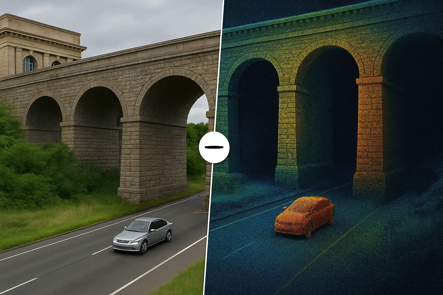
What is LiDAR?
LiDAR, short for Light Detection and Ranging, is a remote sensing technology that uses laser pulses to measure distances between a sensor and a surface. By calculating the time it takes for each laser pulse to return, LiDAR generates precise, three-dimensional information about the environment.
Originally developed for aerospace applications in the 1960s, LiDAR is now a cornerstone of modern mapping and analysis. It’s used in everything from autonomous vehicles to coastal monitoring. In infrastructure, its precision and efficiency are game changers.
The main types of LiDAR include:
- Terrestrial LiDAR: Ground-based systems for building scans, bridges, and industrial facilities.
- Aerial LiDAR: Drone, helicopter, or aircraft-mounted sensors ideal for surveying large areas quickly.
- Mobile LiDAR: Vehicle-mounted systems for corridor mapping in roads, railways, pipelines etc.
Why LiDAR Matters for Infrastructure Projects
Infrastructure teams face increasing pressure to work faster, safer, and with greater accuracy. LiDAR checks all three boxes.
Key benefits include:
- Precision: Sub-centimeter accuracy, which is critical for structural analysis and compliance.
- Efficiency: Capture large areas in hours, not days, reducing the need for repeated site visits.
- Safety: Inspect hard-to-reach or hazardous areas remotely.
- Data richness: A single LiDAR scan can support multiple analyses, including structural integrity, asset inventory, and terrain modeling, without requiring a revisit to the site.
Key Applications in Infrastructure
1. Roadway Asset Management
LiDAR enables detailed mapping of roadway conditions and associated infrastructure such as signs, poles, and guardrails. Using FusionMap’s Asset Analyzer, these assets can be automatically detected, classified, and geotagged with condition metadata.
2. Bridge & Structure Inspection
With Facade AI™, LiDAR scans can be processed to detect cracks, corrosion, or deformation. Defects are visualized directly on 3D models, making it easier to prioritize repairs and track changes over time.
3. Urban Planning & Smart Cities
City planners use LiDAR-derived 3D models for accurate simulations and infrastructure planning. FusionMap integrates these models with premium geospatial layers for richer context.
4. Flood & Disaster Management
LiDAR’s high-resolution terrain models are invaluable for identifying flood-prone areas, modeling landslide risks, and planning evacuation routes. FusionMap’s Split View lets you compare pre- and post-event datasets instantly.
5. Construction Progress Monitoring
By capturing regular LiDAR scans, project teams can measure progress against design plans. Split View reveals even subtle differences, enabling early intervention if issues arise.
Common Challenges & How FusionMap Overcomes Them
Challenge 1: Large File Sizes
LiDAR datasets can easily exceed gigabytes in size. With Fusion Cloud, teams can bulk upload thousands of LAS files directly to Azure Blob Storage, bypassing browser limitations and keeping data securely accessible.
Challenge 2: Complex Processing Requirements
Processing LiDAR point clouds often requires specialized software. FusionMap’s integrated visualization tools allow you to view, measure, and annotate directly, no external software needed.
Challenge 3: Skill Gaps
Interpreting LiDAR data can be intimidating. With Pulse AI, FusionMap users can ask natural language questions about their data and get immediate, context-aware insights, ultimately reducing the learning curve for new users.
LiDAR + AI = Smarter Infrastructure Decisions
LiDAR provides the raw data. AI transforms it into actionable intelligence.
With FusionMap’s built-in AI solutions:
- Facade AI™ automatically detects façade defects in 3D models.
- Airfield AI™ identifies cracks and surface damage on runways.
- Asset Analyzer detects, classifies, and maps infrastructure assets at scale.
By combining LiDAR’s precision with AI’s automation, FusionMap helps infrastructure teams move from data collection to decision-making in record time.
Conclusion: The Future is LiDAR-Driven
LiDAR is no longer just for specialists; it’s becoming an essential tool for anyone involved in infrastructure planning, inspection, and asset management. When paired with AI and cloud-based workflows, it’s a technology that can drastically improve safety, efficiency, and cost control.
FusionMap puts LiDAR’s full potential at your fingertips by integrating capture, storage, analysis, and AI insights in ONE platform.
✅ Ready to put LiDAR to work for your projects?
Get in touch with us and see how FusionMap’s AI-powered geospatial platform can help you work faster, safer, and smarter.